
Where Flight Simulation Enthusiasts Gather from Around the World!
AVSIM Library - Search Results

| Category: Flight Simulator 2004 - Scenery | |
| Schilthorn "Piz Gloria" |

|
Images related to this file:
File Description:
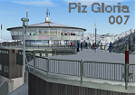
FS2004 Scenery. Schilthorn "Piz Gloria" in Switzerland in 2970 m high. From James Bond 007 "On Her Majesty's Secret Service". Gmax modelled 3D buildings und DXT texture. For FS2004 and Switerland Pro X. Made by Hans-Ruedi Maibach.
| Filename: | Schilthorn_Piz_Gloria.zip |
| License: | Freeware |
| Added: | 4th June 2011, 18:17:05 |
| Downloads: | 881 |
| Author: | Hans-Ruedi Maibach |
| Size: | 34.06 MB |
| Category: Flight Simulator 2004 - Scenery | |
| SACO - Ingeniero Aeronautico Ambrosio L.V. Taravella Int. - Cordoba, Argentina |
|
Images related to this file:
File Description:
FS2004 Scenery Airport Cordoba - Pajas Blancas, Argentina. Ing. Aeronautico Ambrosio Taravella - Argentina
| Filename: | SACO__Ingeniero_Aeronautico_Ambrosio_LV_Taravella_.zip |
| License: | Freeware |
| Added: | 5th June 2011, 15:18:07 |
| Downloads: | 1,805 |
| Author: | Ivano Marongiu |
| Size: | 6.36 MB |
| Category: Flight Simulator 2004 - Scenery | |
| Dresden (EDDC) Tower Extension |
|
Images related to this file:
File Description:
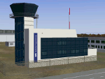
This tower building extends the "German Airports" scenery for Dresden-Klotzsche Airport (EDDC) to the lack of tower building.
| Filename: | Dresden_EDDC_Tower_Extension.zip |
| License: | Freeware |
| Added: | 6th June 2011, 18:06:46 |
| Downloads: | 859 |
| Author: | Uwe Kunzak |
| Size: | 693.66 KB |
| Category: Flight Simulator 2004 - Scenery | |
| Puerto Rico, Isla de la Culebra, Benjamin Rivera Airport (CPX) v1.0 |
|
Images related to this file:
File Description:
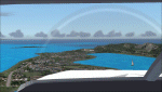
The Benjamin Rivera airport on Culebra Island in Puerto Rico. Added taxiways, terminals gate and parking. Works with the standard terrain or with the enhanced mesh by Jorge Robles (available here - puertoricomesh.zip).
Also includes a voice modification for the airport callsign (requires EditVoicepack to work)
| Filename: | Puerto_Rico_Isla_de_la_Culebra_Benjamin_Rivera_Air.zip |
| License: | Freeware, limited distribution |
| Added: | 6th June 2011, 18:23:04 |
| Downloads: | 483 |
| Author: | Alf B. Meier |
| Size: | 86.54 KB |
| Category: Flight Simulator 2004 - Scenery | |
| Moore-Murrell Airport KMOR |
|
Images related to this file:
File Description:
FS2004 Scenery - Moore-Murrell Airport (KMOR) serves Morristown and Hamblen County and is owned by the City Of Morristown, TN. The paved runway extends for 5701 feet. The facility is at an elevation of 1313 feet at a distance of about 4 miles from Morristown. This scenery employs the usual scenery objects libraries. Check the readme file for more information. Original concept and design by Maurice Butz in collaboration with John B. LOney, Jr.
| Filename: | MooreMurrell_Airport_KMOR.zip |
| License: | Freeware, limited distribution |
| Added: | 10th June 2011, 09:07:28 |
| Downloads: | 301 |
| Author: | Maurice Butz and John B Loney Jr |
| Size: | 1.2 MB |
| Category: Flight Simulator 2004 - Scenery | |
| Birmingham Xtreme |
|
Images related to this file:
File Description:

Version2 remake of this extremely accurate scenery for Birmingham International Airport, UK. Includes night lighting, large amount of animation vehicles,replacement AFCAD2 file. All textures made to the highest standard based on actual photographs. DEMO VERSION ONLY, functional but has 'demo signs'
| Filename: | Birmingham_Xtreme.zip |
| License: | Commercial demo |
| Added: | 10th June 2011, 11:45:31 |
| Downloads: | 1,133 |
| Author: | Gary Summons - UK2000 Scenery |
| Size: | 80.54 MB |
| Category: Flight Simulator 2004 - Scenery | |
| Arctic Runway Signs in the "Northern Domestic Airspace", Canada |
|
Images related to this file:
File Description:
These are scenery bgl's to replace those previously posted for Cape Dorset, Gjoa Haven, Igloolik, and Whale Cove. All of these airfields are within what is marked on the chart as "Northern Domestic Airspace" and their runway signage is not given as a magnetic bearing but as a true bearing. This is because at those latitudes, close to magnetic north, the magnetic field is more vertical than horizontal and magnetic readings become unreliable. Planes report their course as a true course, and fly at a height that reflects their true course instead of their magnetic course. The picture shows the runway sign for Qikiqtarjuaq CYVM (which used to be called Broughton Island) which I am working on right now, and I realised that my training was so far behind me that I had forgotten all of the above. The boundary line of the two air spaces is not a straight line; the furthest south it reaches is on the west coast of Hudson Bay just north of Churchill. To the east it passes through the southern end of Baffin Island, and to the west it is north of the coast at the Alaskan border, and there is an illustration included here.
| Filename: | Arctic_Runway_Signs_in_the_Northern_Domestic_Airsp.zip |
| License: | Freeware, limited distribution |
| Added: | 11th June 2011, 03:06:36 |
| Downloads: | 310 |
| Author: | Roger Wensley |
| Size: | 1.21 MB |
| Category: Flight Simulator 2004 - Scenery | |
| Syracuse NY (KSYR) |
|
Images related to this file:
File Description:
This is Syracuse NY (KSYR)based upon photos I took when I flew there and Bing maps photos.
| Filename: | Syracuse_NY_KSYR.zip |
| License: | Freeware |
| Added: | 11th June 2011, 22:47:51 |
| Downloads: | 1,591 |
| Author: | Eric Cagan |
| Size: | 5.7 MB |
| Category: Flight Simulator 2004 - Scenery | |
| KIWA Phoenix Mesa-Gateway 2011 |
|
Images related to this file:
File Description:
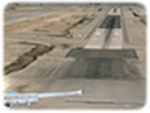
My first airport featuring the spectacular Phoenix Mesa-Gateway (Updated Installer)
Features: 3D Taxiway lights, Gmax buildings, Animated Traffic, and Photoreal Ground/Aerial imagery.
| Filename: | KIWA_Phoenix_MesaGateway_2011.zip |
| License: | Freeware |
| Added: | 13th June 2011, 13:47:01 |
| Downloads: | 2,308 |
| Author: | Ryan Whitford |
| Size: | 24.16 MB |
| Category: Flight Simulator 2004 - Scenery | |
| Qikiqtarjuaq CYVM (Broughton) and DEW FOX-5 in Nunavut, Canada |
|
Images related to this file:
File Description:
Qikiqtarjuaq is an airfield on the northeast coast of Baffin Island, just over 100 miles north of Pangnirtung. The airfield is the closest Canadian airfield to Greenland and is used for ferry flights from Canada to Europe for small planes, though there is normally only JetA1 fuel available. The airfield is at only 18 feet ASL next to the sea with the village to the north; it was previously (before 1998) called Broughton Island. The runway is 3,800' of 100' wide gravel and is lighted; as it is in the Northern Domestic Airspace the runway is signed as 033T-213T, using "true" bearings instead of magnetic. There is a terminal and a small maintenance building on the apron and these have been modeled specifically for this scenery. There are AI parking spots; the AI visiting aircraft are a Canadian North Dash 8 and a First Air 42-300. Qikiqtarjuaq village is just north of the airfield and has a population of around 520; it is approximately the right size and shape but no buildings were specifically modeled for the village. There is also a North Warning System site called Fox-5 to the northeast, and this too is included. You will need Ultimate Terrain Alaska Canada.
| Filename: | Qikiqtarjuaq_CYVM_Broughton_and_DEW_FOX5_in_Nunavu.zip |
| License: | Freeware, limited distribution |
| Added: | 14th June 2011, 02:04:26 |
| Downloads: | 559 |
| Author: | Roger Wensley |
| Size: | 1.85 MB |


© 2001-2026 AVSIM Online
All Rights Reserved
Privacy Policy |