
Where Flight Simulation Enthusiasts Gather from Around the World!
AVSIM Library - Search Results

| Category: Flight Simulator 2004 - Scenery | |
| Grosseto Airbase (LIRS) |

|
File Description:
FS2004 Grosseto Airbase, Tuscany, Italy. ADE9X scenery made using the MAIW libraries and featuring custom objects kindly provided by Timothy Mayhew.
Please check the readme for installation instructions and other useful information.
| Filename: | Grosseto_Airbase_LIRS.zip |
| License: | Freeware |
| Added: | 14th May 2011, 22:19:37 |
| Downloads: | 2,586 |
| Author: | Giacomo Gramazio, Timothy Mayhew |
| Size: | 798.99 KB |
| Category: Flight Simulator 2004 - Scenery | |
| Key West EYW / KEYW |
|
Images related to this file:
File Description:

FRF Studio presents Key West, Florida. One of the smallest US airports to still host mainline service, KEYW has been modelled in great detail from the ground up. This project also reflects the recent upgrades to the main terminal. Static aircraft populate the tiny field as well as a representation of Hwy 1 which extends from Key West to mainland Florida via numerous island-hopping bridges. This scenery is compatible with FreeFlow Florida, and was made with FlightOne's Instant Scenery.
| Filename: | Key_West_EYW__KEYW.zip |
| License: | Freeware |
| Added: | 15th May 2011, 21:56:01 |
| Downloads: | 4,418 |
| Author: | www.FRFStudio.net / William Morgan |
| Size: | 15.03 MB |
| Category: Flight Simulator 2004 - Scenery | |
| Madeira (LPPS) |
|
Images related to this file:
File Description:
Addon for the scenario of Madeira of Toni Agramont (madeira_271158.zip) download in this web!!! with AFCAD of LPPS near the reality and adapted to its scenario. In this airport has been included his military zone, the letters with the name of the airport and some elements that let you discover: fly to the port from 21: 00 h and you will be surprised. We have included many objects Rwy12, also of other creators and created by me, all to enhance the landscape. Without Rwy12 it will also work but it is recommended strongly install base libraries to enjoy it the most. Rreadme.txt for download links and the correct installation of this scenario.
| Filename: | Madeira_LPPS.zip |
| License: | Freeware |
| Added: | 16th May 2011, 22:03:49 |
| Downloads: | 3,693 |
| Author: | Jordi Reco |
| Size: | 6.96 MB |
| Category: Flight Simulator 2004 - Scenery | |
| Pangnirtung CYXP scenery for FS9 |
|
Images related to this file:
File Description:
Located about 160 miles NE of Iqaluit on the spectacular Pangnirtung fjord. "Pang" is know primarily for its Turbot fishing industry and its high quality native artwork. This is a complete replacement for the incomplete and inaccurate default scenery. Custom terminal with photo textures, and all the usual goodies.
| Filename: | Pangnirtung_CYXP_scenery_for_FS9.zip |
| License: | Freeware |
| Added: | 20th May 2011, 21:59:03 |
| Downloads: | 709 |
| Author: | Sidney Schwartz |
| Size: | 1.52 MB |
| Category: Flight Simulator 2004 - Scenery | |
| Ulukhaktok (Holman) CYHI in the Northwest Territories, Canada |
|
Images related to this file:
File Description:
Ulukhaktok (Holman) is an airfield on the west side of Victoria Island, off the northern coast of Canada. It is 320 miles west of Cambridge Bay (and you should download and install the recent post of CYCB by Sid and Pete, as I use it for the AI included in this post) and around 400 miles east of Inuvik (my post of a few months ago). It has been officially called Ulukhaktok since 2006, and before that it's name was Holman.
The village of Ulukhaktok has been placed around the bay and is approximately the right shape; it houses some 460 people who used to rely solely on hunting and fishing. The village is close to 71 degrees north, and there are only four months of the year when the average high is above zero centigrade. The photograph with snow (and of course a frozen sea) is typical; for the frozen sea download my Frozen Rivers & Lakes post which will provide this. The buildings on the field have been modelled specifically for this scenery, and as in real life there is only JetA available. The AI visiting aircraft are an Aklak Air DC3 (based in Inuvik and operated by Kenn Borek Air) and a Canadian North Dash 8-100. Note that the runways are signed as "true" headings instead of magnetic; in the Canadian Northern Domestic Airspace all headings are given as true. Unfortunately FS9 doesn't accommodate this in ATC.
| Filename: | Ulukhaktok_Holman_CYHI_in_the_Northwest_Territorie.zip |
| License: | Freeware, limited distribution |
| Added: | 24th May 2011, 20:05:47 |
| Downloads: | 454 |
| Author: | Roger Wensley |
| Size: | 2.3 MB |
| Category: Flight Simulator 2004 - Scenery | |
| El Formosa - Taiwan Scenery Project, Part 11 Patch 1 |
|
File Description:
This patch corrects el Formosa - Taiwan Scenery Project Part 11 Taoyuan International Airport (RCTP) runway 24, 23 distance remaining signs. Missed approach procedure and terminal 2 truss structure are also included.
| Filename: | El_Formosa__Taiwan_Scenery_Project_Part_11_Patch_1.zip |
| License: | Freeware, limited distribution |
| Added: | 27th May 2011, 03:54:58 |
| Downloads: | 5,232 |
| Author: | Formosa Group |
| Size: | 83.02 KB |
| Category: Flight Simulator 2004 - Scenery | |
| Nanisivik CYSR and Arctic Bay CJX7 in Nunavut, Canada |
|
Images related to this file:
File Description:
Nanisivik is an airfield in the north of Baffin Island, 470 miles north of the Arctic circle. It was built to service a zinc and lead mine that was opened in 1976 as Canada's first Arctic mine, now closed and dismantled. The deep water Strathcona Sound has been ear-marked by the Canadian government for development as a naval base, so I have left the large ore storage shed and the jetty in place. The airfield is at 2,106 feet on the top of the Borden Peninsula hills with a lighted 6,400 feet of 150 feet wide gravel runway runway aligned 11/29. There is a terminal and other maintenance buildings, and First Air have a building there from when the mine generated a lot of traffic and jets were used. Arctic Bay is a village 11 miles west of Nanisivik airfield with a population of around 690 which also uses the Nanisivik airfield. There is another gravel strip much closer to the village that is called Arctic Bay CJX7, but this is smaller with only 1,500' of 50' wide gravel and has no facilities of any sort. The village is partly dependent on visiting sports hunters and other limited tourist visits. At almost 73 degrees north the average year will have only four or even three months where the average high is above freezing. The buildings on the field have been modelled specifically for this scenery, and as in real life there is only JetA available. The AI visiting aircraft are a Kenn Borek Twin Otter and a First Air 42-300. As Nanisivik is in the "Northern Domestic Airspace" the runway is signed in "true" bearings and not magnetic as magnetic compasses become unreliable close to the magnetic pole.
| Filename: | Nanisivik_CYSR_and_Arctic_Bay_CJX7_in_Nunavut_Cana.zip |
| License: | Freeware, limited distribution |
| Added: | 28th May 2011, 19:59:18 |
| Downloads: | 496 |
| Author: | Roger Wensley |
| Size: | 2.64 MB |
| Category: Flight Simulator 2004 - Scenery | |
| Algiers Real Scenery version 1.01 |
|
Images related to this file:
File Description:
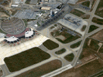
FS2004 Algiers Real Scenery version 1.01 by Riad GHENIM
Algiers DAAG, Algeria, Houari Boumedienne Airport with new parking marks and PAPI for Runway 05.
This scenery needs Algiers City PhotoTerrain scenery available on www.avsim.com
| Filename: | Algiers_Real_Scenery_version_101.zip |
| License: | Freeware |
| Added: | 3rd June 2011, 22:22:18 |
| Downloads: | 12,257 |
| Author: | Riad Ghenim |
| Size: | 19.53 MB |
| Category: Flight Simulator 2004 - Scenery | |
| Algiers City PhotoTerrain Scenery |
|
Images related to this file:
File Description:
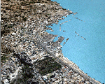
FS2004 Algiers City PhotoTerrain Scenery by Riad GHENIM
Algiers DAAG, Algeria, Mediterannean city.
This phototerrain scenery works with Algiers Real Scenery for FS2004 v1.01
| Filename: | Algiers_City_PhotoTerrain_Scenery.zip |
| License: | Freeware |
| Added: | 3rd June 2011, 22:23:16 |
| Downloads: | 5,955 |
| Author: | Riad Ghenim |
| Size: | 23.88 MB |
| Category: Flight Simulator 2004 - Scenery | |
| Constantine DABC Airport Mohamed Boudiaf |
|
Images related to this file:
File Description:
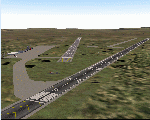
FS2004 Scenery Constantine Mohamed Boudiaf Airport in Algeria, Africa.
Constantine is a small regional airport in North Africa.
Version 1.01 with ILS 34 include.
By Riad Ghenim
| Filename: | Constantine_DABC_Airport_Mohamed_Boudiaf.zip |
| License: | Freeware |
| Added: | 3rd June 2011, 22:31:53 |
| Downloads: | 1,244 |
| Author: | Riad Ghenim |
| Size: | 1.6 MB |


© 2001-2026 AVSIM Online
All Rights Reserved
Privacy Policy |