
Where Flight Simulation Enthusiasts Gather from Around the World!
AVSIM Library - Search Results

| Category: Flight Simulator 2004 - Scenery | |
| Byron Bay CWBB plus Edinburgh Island CWEI in Nunavut, Canada |

|
Images related to this file:
File Description:
Byron Bay was a DEW line station on the south coast of Victoria Island, 105 miles east of Lady Franklin Point. It closed in 1993. The buildings are still there, slowly accumulating the patina so admired by collectors on Antiques Roadshow. The runway is just over 4,500 feet and aligned 58T-238T. At the mid point between Lady Franklin Point and Byron Bay there is a North Warning Site on the highpoint of Edinburgh Island, just south of the closed Ross Point station on the "mainland" Victoria Island. The runway is just over 1,400 feet and is also up on the top of the island. There is a steep road down 600 feet to the coast for the annual fuel resupply and maintenance.
| Filename: | Byron_Bay_CWBB_plus_Edinburgh_Island_CWEI_in_Nunav.zip |
| License: | Freeware, limited distribution |
| Added: | 11th November 2012, 21:07:05 |
| Downloads: | 248 |
| Author: | Roger Wensley |
| Size: | 2 MB |
| Category: Flight Simulator 2004 - Scenery | |
| Sturt Point CWSP in Nunavut, Canada |
|
Images related to this file:
File Description:
Sturt Point was a DEW line I Station on the south coast of Victoria Island, 50 miles east of Cambridge Bay. It was closed in 1963 but remains in place, though a 5 man I Station has such a small impact on its surroundings that it is hardly visible. The runway is 3,420 feet of gravel aligned 117T/297T, and there are no lights, signage, or windsock, but there are ruts in the gravel. A North Warning System station was built 15 miles inland and closer to Cambridge Bay, operating from 1991 onwards. This has a short (1,280'?) gravel runway aligned 138T/318T (and named CWSX here). No ruts in the gravel, but also still no lights, signage, or windsock.
| Filename: | Sturt_Point_CWSP_in_Nunavut_Canada.zip |
| License: | Freeware, limited distribution |
| Added: | 11th November 2012, 21:07:18 |
| Downloads: | 209 |
| Author: | Roger Wensley |
| Size: | 1.35 MB |
| Category: Flight Simulator 2004 - Scenery | |
| Sembach Air Base 1990 |
|
Images related to this file:
File Description:
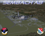
This scenery is a representation of Sembach Air Base in the former West Germany during 1990. At the time, Sembach was host to the 66th Electronic Combat Wing, which was responsible for the home-based EC-130H "Compass Call" aircraft of the 43rd Electronic Combat Squadron, and also had in-direct control of the 42nd Electronic Combat Squadron based at RAF Upper Heyford in the U.K. flying the Grumman EF-111A Raven.
The 66th ECW moved into Sembach during 1986, and spent the next six years flying from there. The role of the aircraft was electronic disruption of enemy radio and radar transmissions, to limit the enemies ability to co-ordinate their own forces and also the transmission of propaganda in an attempt to win hearts and minds.
Sembach was also known as Det.1 of the 81st Tactical Fighter Wing, based at the Twin Bases complex of RAF Woodbridge and RAF Bentwaters. The A-10A's of the six squadrons there would regularly deploy to Sembach and other Forward Operating Locations (FOLs) within West Germany, which was a part of their war-time role.
Included in this package are repaints of all six EC-130H's present at Sembach as of April 1990.
| Filename: | Sembach_Air_Base_1990.zip |
| License: | Freeware, limited distribution |
| Added: | 14th November 2012, 01:37:20 |
| Downloads: | 1,378 |
| Author: | Brian Clarke, Chris A. Brown, Daryl Payne, Stewart Pearson |
| Size: | 1.75 MB |
| Category: Flight Simulator 2004 - Scenery | |
| Jenny Lind Island CWJL in Nunavut, Canada |
|
Images related to this file:
File Description:
This was a DEW line Auxiliary Station on Jenny Lind Island; the island is about 14 miles by 12 miles and off the southeast corner of Victoria Island, 85 miles east of Cambridge Bay. The station was closed in 1992 but is still there as "closed" meant "shut the door and walk away". There has been some later removal of diesel tanks and other polluting items but the buildings are still intact, and the runway is 4,470 feet of gravel 150' wide. At the western end there is an apron and a large hangar. There are of course no lights, signage, or windsock. A North Warning System station was built in 1990, 6 miles inland to the northwest of the runway. This has a shorter (1,400'?) gravel runway (and named CWJX here).
| Filename: | Jenny_Lind_Island_CWJL_in_Nunavut_Canada.zip |
| License: | Freeware, limited distribution |
| Added: | 15th November 2012, 13:55:29 |
| Downloads: | 191 |
| Author: | Roger Wensley |
| Size: | 1.65 MB |
| Category: Flight Simulator 2004 - Scenery | |
| Hat Island CWHI in Nunavut, Canada |
|
Images related to this file:
File Description:
This was a DEW line I Station on Hat Island; the island is around 4 miles square and just under 50 miles southeast of Jenny Lind Island. The station was closed in 1963 and has now been totally dismantled and removed, a fairly easy task given the size. The runway is still there and is a shade over 3,000 feet of gravel 100' wide. There are no lights, signage, or windsock. A North Warning System station was built in 1991 on the site of the I Station, just north of the runway. Most of these DEW line stations are not particularly impressive or even interesting. However, you can bet that any pilot flying regularly in the north along the coast knows where all these runways are, in case one of them suddenly becomes his favourite in the whole world just after the sudden silence.
| Filename: | Hat_Island_CWHI_in_Nunavut_Canada.zip |
| License: | Freeware, limited distribution |
| Added: | 15th November 2012, 13:55:41 |
| Downloads: | 197 |
| Author: | Roger Wensley |
| Size: | 1.08 MB |
| Category: Flight Simulator 2004 - Scenery | |
| TISX - Henry E. Rohlsen Intl. - St. Croix Virgin Islands |
|
Images related to this file:
File Description:
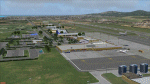
"Henry E-Rohlsen Intl ( TISX ) " is the Scenery of the International Airport of Saint-Croix Island,located in The U.S. Virgins Islands south of Puerto Rico not far from Saint-Thomas Island.
| Filename: | TISX__Henry_E_Rohlsen_Intl__St_Croix_Virgin_Island.zip |
| License: | Freeware |
| Added: | 15th November 2012, 17:30:34 |
| Downloads: | 1,201 |
| Author: | Delblond Christian |
| Size: | 5.64 MB |
| Category: Flight Simulator 2004 - Scenery | |
| Arnot Power Station, South Africa |
|
Images related to this file:
File Description:
Arnot Power Station, South Africa with photoreal textures and seasonal textures.
The power station, airfield building, objects and fences were all custom made in Gmax, while Rietkuil village (Arnot) is also represented by means of almost 800 hand placed autogen buildings. Arnot is also well known for the large amount of trees in the area, on approach to rwy 13 and lining the road seperating the village from the power station, and these are also represented by more than 4 000 hand placed trees. The "Ash-dam" south of the runway is also included.
| Filename: | Arnot_Power_Station_South_Africa.zip |
| License: | Freeware, limited distribution |
| Added: | 16th November 2012, 23:45:27 |
| Downloads: | 545 |
| Author: | Kobus van Wyk |
| Size: | 11.86 MB |
| Category: Flight Simulator 2004 - Scenery | |
| Sembach AB *Patch* |
|
File Description:
This will replace the bright green grass with a background poly to make the base blend in a bit better. Thanks to Stewart Pearson for the patch.
| Filename: | Sembach_AB_Patch.zip |
| License: | Freeware, limited distribution |
| Added: | 17th November 2012, 19:44:34 |
| Downloads: | 797 |
| Author: | Brian Clarke, Stewart Pearson, Daryl Payne |
| Size: | 16.71 KB |
| Category: Flight Simulator 2004 - Scenery | |
| CWGP- Gladman Point - Nunavut, Canada |
|
Images related to this file:
File Description:
This is a DEW line Auxiliary Station on the south shore of King William Island; the island is around 70 miles square and Gjoa Haven is on the southeast corner. The station was closed in 1992 and has now been totally dismantled and removed, a pollutant hazard for the inhabitants of Gjoa Haven. The runway is still there and is a shade over 5,000 feet of gravel 150' wide. There are no lights, signage, or windsock, and in this case even the hangar has gone. A North Warning System station was built in 1990 on a small part of the site of the DEW Station, north of the runway.
| Filename: | CWGP_Gladman_Point__Nunavut_Canada.zip |
| License: | Freeware, limited distribution |
| Added: | 18th November 2012, 09:21:52 |
| Downloads: | 209 |
| Author: | Roger Wensley |
| Size: | 1.23 MB |
| Category: Flight Simulator 2004 - Scenery | |
| CYYH - Taloyoak - Nunavut, Canada |
|
Images related to this file:
File Description:
Taloyoak is on the coast of northern mainland Canada, on the west of the Boothia Peninsula, where it is at it's narrowest. Gjoa Haven is 80 miles southwest, and Hall Beach is 300 miles to the east. Taloyoak was established around a Hudson Bay trading post that was relocated from Fort Ross in 1948 because of poor ice conditions. There is now a clinic, school, church, recreation centre, two markets, two small hotels, and housing for the population of around 900. The airfield is to the west of the village on higher ground at 92 feet asl, and the 4,020 feet of 100 feet wide gravel runway is aligned 151T/331T where T stands for "true" as opposed to magnetic in the Northern Domestic Airspace. Only JETA-1 is available, unless there is some 100LL in drums. There are flights by First Air and Canadian North and the AI includes a daily flight of each, plus an afternoon cargo visit by a Buffalo C46; the closest large city is Yellowknife, 750 miles southwest.
| Filename: | CYYH__Taloyoak__Nunavut_Canada.zip |
| License: | Freeware, limited distribution |
| Added: | 18th November 2012, 09:23:20 |
| Downloads: | 379 |
| Author: | Roger Wensley |
| Size: | 3 MB |


© 2001-2026 AVSIM Online
All Rights Reserved
Privacy Policy |