
Where Flight Simulation Enthusiasts Gather from Around the World!
AVSIM Library - Search Results

| Category: Flight Simulator 2004 - Scenery | |
| Vargarda airfield |

|
Images related to this file:
File Description:
Version 1.1 ; Vargarda airfield is a small airfield outside allingsas used by the Parachute Club Cirrus Goteborg, more info here: http://www.flygkartan.se/053695/Vargarda_flygfalt ; I used AFCAD to do the layout and instant scenery to place the building.
| Filename: | Vargarda_airfield.zip |
| License: | Freeware, limited distribution |
| Added: | 2nd July 2011, 17:53:22 |
| Downloads: | 158 |
| Author: | Max August, Larsson Kuhla |
| Size: | 52.52 KB |
| Category: Flight Simulator 2004 - Scenery | |
| Rodos Photoreal Autogen |
|
File Description:
The autogen (buildings and trees) for the Korkidas Makis's "Rodos photoreal" scenery distributed by Hvacc.org. More informations in readme.
| Filename: | Rodos_Photoreal_Autogen.zip |
| License: | Freeware |
| Added: | 2nd July 2011, 17:56:22 |
| Downloads: | 1,040 |
| Author: | Luca Esposito |
| Size: | 3.46 MB |
| Category: Flight Simulator 2004 - Scenery | |
| KADW Joint Base Andrews Naval Air Facility, Maryland, USA (Andrews Air Force Base) |
|
Images related to this file:
File Description:
This is the first version of my scenery for the Joint Base Andrews Naval Air Facility, Maryland, USA - better known as Andrews Air Force Base.
The main buildings, fences, tanks and other objects are completely self-created, modeled with GMAX and covered with self-created textures. For this I have used GIMP - and of course DXTBMP.
For the trees, cars and other items I have used already existing libraries and others like Matt Tomkins' MTtrees, Sidney Schwartz' ESDG Ramp Lights and Lars Hoyer's Extra Objects. Furthermore MAIW's (Military AI Works) airplanes are used to fill the apron with static aircraft. A complete list of used libraries you will find in the readme file.
| Filename: | KADW_Joint_Base_Andrews_Naval_Air_Facility_Marylan.zip |
| License: | Freeware |
| Added: | 5th July 2011, 03:58:27 |
| Downloads: | 3,869 |
| Author: | Uwe Kunzak |
| Size: | 71.13 MB |
| Category: Flight Simulator 2004 - Scenery | |
| Perrine Bridge, Twin Falls Idaho Updated |
|
Images related to this file:
File Description:
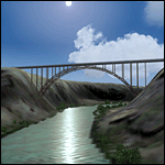
A prominent VFR landmark near Twin Falls Idaho, the Perrine Bridge spans over 1600' and stands 486 feet above the river below. At one time it was the tallest bridge in the world. Perrine Bridge is the only man-made structure in the USA were "base jumping" is allowed without a permit 365 days out of the year. Download includes gmax bridge object, a small photoscenery for the surrounding area, and two saved flight scenarios for exploring the scenery in the default J3 Cub. Bridge surface is landable and crash box has been removed allowing flight beneath the bridge. Scenery is compatible with, and nicely compliments John B. Loney's "Joslin-Magic Valley Regl" airport scenery (ktwf_v1.zip). Requires Ultimate Terrain and freeware mesh product, links provided in the readme.
| Filename: | Perrine_Bridge_Twin_Falls_Idaho_Updated.zip |
| License: | Freeware, limited distribution |
| Added: | 5th July 2011, 04:28:11 |
| Downloads: | 411 |
| Author: | Jim Robinson |
| Size: | 1.52 MB |
| Category: Flight Simulator 2004 - Scenery | |
| McChord AFB Washington, USA |
|
Images related to this file:
File Description:

Scenery for McChord AFB. Features custom buildings and photo-realistic (default resolution) terrain. Designed for use with the MAIW C-17 West package available at http://www.militaryaiworks.com This is a stand alone package but may benefit from additional downloads, see readme file inside.
| Filename: | McChord_AFB_Washington_USA.zip |
| License: | Freeware, limited distribution |
| Added: | 6th July 2011, 03:25:15 |
| Downloads: | 2,396 |
| Author: | John Stinstrom |
| Size: | 2.05 MB |
| Category: Flight Simulator 2004 - Scenery | |
| RAF Akrotiri |
|
Images related to this file:
File Description:
Scenery & afcad for RAF Akrotiri, Cyprus. You'll need some packages from MAIW to see the buildings, please read the readme for details.
| Filename: | RAF_Akrotiri.zip |
| License: | Freeware |
| Added: | 7th July 2011, 00:03:57 |
| Downloads: | 1,395 |
| Author: | Daniel Reeves |
| Size: | 41.15 KB |
| Category: Flight Simulator 2004 - Scenery | |
| KMYR Myrtle Beach, SC. |
|
Images related to this file:
File Description:

KMYR for FS9. Complete new terminal with jetways and correct airline parking. New hangers and general aviation area. Added Hotels on the beach front.
Requires the complete RWY12 object library and the complete EZ Scenery object library. Links included in the READ ME file.
| Filename: | KMYR_Myrtle_Beach_SC.zip |
| License: | Freeware |
| Added: | 8th July 2011, 01:34:40 |
| Downloads: | 1,535 |
| Author: | Rob Touchtone |
| Size: | 24.33 MB |
| Category: Flight Simulator 2004 - Scenery | |
| Leeuwarden AB |
|
Images related to this file:
File Description:

Scenery for Leeuwarden AB, Netherlands. You'll need certain packages from MAIW to see the eye candy, check the readme for details.
| Filename: | Leeuwarden_AB.zip |
| License: | Freeware |
| Added: | 10th July 2011, 09:44:11 |
| Downloads: | 803 |
| Author: | Daniel Reeves |
| Size: | 53.46 KB |
| Category: Flight Simulator 2004 - Scenery | |
| The Real Colombo |
|
Images related to this file:
File Description:
This is the complete & high detailed scenery of Colombo Municipal area
for Microsoft Flight Simulator 2004. If you are a Sri Lankan flightsimmer or like to fly
around Sri Lanka in Flight Simulator 2004, then this is a must for you!.
Features* -: Accurate building placements.
Some of city's icon buildings.
Custom G-max buildings and other objects.
High quality Satellite terrain.
High detailed Autogen data.
Animated road traffic at night.
Specially high detailed colombo harbour.
| Filename: | The_Real_Colombo.zip |
| License: | Freeware, limited distribution |
| Added: | 10th July 2011, 15:44:14 |
| Downloads: | 1,110 |
| Author: | Gayan Liyanaarachchi |
| Size: | 14.29 MB |
| Category: Flight Simulator 2004 - Scenery | |
| Cape Hooper CWFH and FOX-4 DEW Line Station in Nunavut, Canada |
|
Images related to this file:
File Description:
Cape Hooper is around 60 miles north of Kivitoo (FOX-D) and 140 miles south of Clyde River CYCY on the northeast-facing coast of Baffin Island. FOX-4 is still in use as a new and mostly-unmanned North Warning System site was established there in 1990 before the DEW line station was closed in 1991. Actually the DEW line station was not "closed" as such, they just stopped using it. The site of FOX-4 is on the top of a bump at the end of one of many long promontories that stick out into the Davis Strait between Baffin Island and Greenland, close to the far eastern end that is called Cape Hooper. There is a gravel runway to the west, down at 65' ASL; it is only just over 3,000' long and most material was delivered by sea to the beach at the southern end of the runway. The runway is signed as
"324T - 144T" as this is Northern Domestic Airspace where all runways are signed "true" and not "magnetic"; it is 013/193 magnetic with a huge magnetic variation of 48.9 degrees in this area where the magnetic field is mostly vertical, and so useless for navigation.
| Filename: | Cape_Hooper_CWFH_and_FOX4_DEW_Line_Station_in_Nuna.zip |
| License: | Freeware |
| Added: | 11th July 2011, 00:28:40 |
| Downloads: | 416 |
| Author: | Roger Wensley |
| Size: | 1.65 MB |


© 2001-2026 AVSIM Online
All Rights Reserved
Privacy Policy |