
Where Flight Simulation Enthusiasts Gather from Around the World!
AVSIM Library - Search Results

| Category: Flight Simulator 2004 - Scenery | |
| Rapid City Regional Airport version 3 |

|
File Description:
This is version 3 of my Rapid City Regional airport. There were problems with the flatten elevation, and I decided to redo the AFCAD to eliminate the various flatten files and rebuilt the taxisigns with ADE 1.50. These files will replace all other versions.
| Filename: | Rapid_City_Regional_Airport_version_3.zip |
| License: | Freeware |
| Added: | 20th March 2012, 01:33:44 |
| Downloads: | 747 |
| Author: | Eric Cagan |
| Size: | 2.49 MB |
| Category: Flight Simulator 2004 - Scenery | |
| Murray Field KEKA |
|
Images related to this file:
File Description:
FS2004 Scenery - Murray Field (IATA: EKA, ICAO: KEKA, FAA LID: EKA) is a county-owned public-use airport in Humboldt County, California, United States. Murray Field Airport serves Eureka and Humboldt County. The airport has more than one runway. The longest is a paved runway extending 3000 feet. The facility is at an elevation of 7 feet at a distance of about 3 miles from Eureka. The airport is primarily used for general aviation. Also FedEx Express utilizes the small airport as a stop for package delivery from and to Humboldt County. Murray Field was first established in 1919 by pilot Dayton Murray, and was later renamed in his honor. It has a restaurant and a charter service, Northern Air, as well as a Civil Air Patrol office. Created by John B. Loney, Jr.
| Filename: | Murray_Field_KEKA.zip |
| License: | Freeware, limited distribution |
| Added: | 20th March 2012, 01:35:39 |
| Downloads: | 346 |
| Author: | John B. Loney, Jr. |
| Size: | 5.92 MB |
| Category: Flight Simulator 2004 - Scenery | |
| Loney's Washington State |
|
Images related to this file:
File Description:
FS2004 Scenery - Loney's Washington State scenery. This scenery has 5 airports located in Washington state. They include Crest Airport (S36) in Kent, WA, Elma Municipal Airport (4W8) in Elma, WA, D and B Airpark (84WA) also in Elma, WA, The now closed Martha Lake Airport (S13) in Alderwood, WA and Whidbey Airpark (W10) in Langley, WA. Created by John B. Loney, Jr.
| Filename: | Loneys_Washington_State.zip |
| License: | Freeware, limited distribution |
| Added: | 20th March 2012, 01:36:13 |
| Downloads: | 568 |
| Author: | John B. Loney, Jr. |
| Size: | 5.98 MB |
| Category: Flight Simulator 2004 - Scenery | |
| Gananoque CNN8 in Ontario, Canada |
|
Images related to this file:
File Description:
Gananoque is an ex-RCAF airfield 20 miles east of Kingston and Lake Ontario and 5 miles north of the Thousand Islands area of the St. Lawrence River and the US border. The airfield was a relief landing field for Kingston during WW2 and opened in 1940 with the classic triangle of runways. It closed in 1945 and is now a sky diving centre, still with the original single hangar and control tower. Fuel is no longer sold there so the only reason to pass by is as part of a visit to the Thousand Islands area, or perhaps look at the Canso (Canadian name for the PBY Catalina) which I understand is in the hangar. Unfortunately, when I turned up there was nobody there. The runways and the taxiways and the apron are all still usable but in what can only be called a state of random disrepair. Centre lines and signage are luxuries. I have included a photo with runway headings indicated.
| Filename: | Gananoque_CNN8_in_Ontario_Canada.zip |
| License: | Freeware, limited distribution |
| Added: | 22nd March 2012, 17:27:11 |
| Downloads: | 287 |
| Author: | Roger Wensley |
| Size: | 3.2 MB |
| Category: Flight Simulator 2004 - Scenery | |
| KDAY Cox-Dayton Intl Airport |
|
File Description:
A complete rework of KDAY for FS2004. Jetways have been added as well as correct gate placement and airline parking codes. The default terminal has been reworked and modified to show the new bagroom near the B Concourse. Apron has been resized. Multiple vehicles have been added to give a more real terminal feel. New Tower location added. Most building objects are generic textures. Recommend AEU7.zip for best texture appearance. by Brian Good
| Filename: | KDAY_CoxDayton_Intl_Airport.zip |
| License: | Freeware |
| Added: | 26th March 2012, 10:54:27 |
| Downloads: | 537 |
| Author: | Brian Good |
| Size: | 10.53 MB |
| Category: Flight Simulator 2004 - Scenery | |
| Aasiaat BGAA on the west coast of Greenland |
|
Images related to this file:
File Description:
I wrote that Qikiqtarjuaq, on the east coast of Baffin Island, was the jumping off airfield for ferry flights for small planes from Canada to Europe via Greenland. Aasiaat is the airfield in Greenland that they jump to, 300 miles across the Davis Strait. The airfield is on the northern coast of Aasiaat Island, and the town of the same name is just two miles to the west. The runway is 2,600 feet of asphalt almost 100 feet wide and lit, at 74 feet ASL, aligned 12/30, with the apron and terminal building at the western end. Air Greenland run regular flights with a Dash-7 or 8, & Twin Otters, and the markings for the taxiway and parking spot in front of the terminal are exactly as they were six years ago. I have seen video since then that has further taxiway and parking spot markings added in, but I like the simplicity of the original. Unfortunately, given the limitations of FS and the single runway and simple taxiway routing there was no way to replicate both the parking facing away from the terminal AND the "through" taxiing to complete the circle back to the runway; after parking correctly the AI Air Greenland Dash-8 will reverse before heading out to take off. There is both JetA and 100LL fuel available. The surrounding area is rocky, and there is no grass around the runway; the airfield has compacted gravel instead.
| Filename: | Aasiaat_BGAA_on_the_west_coast_of_Greenland.zip |
| License: | Freeware, limited distribution |
| Added: | 26th March 2012, 11:01:16 |
| Downloads: | 692 |
| Author: | Roger Wensley |
| Size: | 2.73 MB |
| Category: Flight Simulator 2004 - Scenery | |
| Wellington International and City |
|
File Description:
The 'Real New Zealand' Wellington International and City scenery previously available as payware is now offered here as freeware.
Includes a custom-built airport and city, based on a photo scenery which covers the greater Wellington area.
| Filename: | Wellington_International_and_City.zip |
| License: | Freeware, limited distribution |
| Added: | 31st March 2012, 04:17:09 |
| Downloads: | 6,051 |
| Author: | Robin Corn, Ian Warren |
| Size: | 81.79 MB |
| Category: Flight Simulator 2004 - Scenery | |
| Hellas Scenery Project (HSP), Greece - FIX for Istanbul Marmara sea scenery |
|
Images related to this file:
File Description:
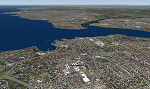
Istanbul Marmara sea FS2004 add on scenery's coastline in Turkey gets affected by HSP base scenery of Greece. With this add on file you fix the affected coastline errors.
The Marmara sea scenery for FS9 may be found as marmara.zip or Marmara%20VFR.rar in various sites. This fix is ONLY for cases where you have also installed Greece BASE package scenery from Hellas Scenery Project (HSP). If you do not have this scenery installed you do not need this fix for the Marmara sea scenery.
| Filename: | Hellas_Scenery_Project_HSP_Greece__FIX_for_Istanbu.zip |
| License: | Freeware |
| Added: | 1st April 2012, 16:56:24 |
| Downloads: | 6,188 |
| Author: | Hellas Scenery Team (HST) |
| Size: | 754.13 KB |
| Category: Flight Simulator 2004 - Scenery | |
| Marlborough, New Zealand - airports and photo scenery |
|
File Description:
The 'Real New Zealand' Marlborough scenery previously available as payware is now offered here as freeware (the scenery and installer are unaltered from the original payware version). Includes custom-built Woodbourne, Omaka and Picton airports, based on a photo scenery which covers much of the Marlborough area.
| Filename: | Marlborough_New_Zealand__airports_and_photo_scener.zip |
| License: | Freeware, limited distribution |
| Added: | 2nd April 2012, 11:49:02 |
| Downloads: | 1,786 |
| Author: | Robin Corn, Ian Warren |
| Size: | 116.09 MB |
| Category: Flight Simulator 2004 - Scenery | |
| Sunnyvale Air Station circa 1933 |
|
Images related to this file:
File Description:
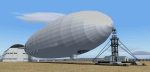
FS2004 Scenery for Sunnyvale Air Station circa 1933. Known for 75 years as Moffett Field Naval Air Station, this unique site started life as Sunyvale Field (then Air Station) and was planned as the west coast base of the new Dirigible U.S.S. Macon.
The Macon was a new direction for airships in that it carried a squadron of fighter/scout aircraft and would provide for the U.S. Navy a 'carrier in the sky'. To provide for this new queen of the skies a new base was created with a unique hangar, for many years the largest free-standing wood construction in world.
This scenery attempts to capture Sunnyvale as it was first opened in 1933. I have taken a few liberties like adding in full grown trees that were part of the original master plan but I believe you will find this base captures the spirit of the original. Scenery contains custom FSDS and Gmax models as well as period AI from J.R. Lucariny (F9C SParrowhawk) and a custom repaint of the default Ford Trimotor by Ed Moore and Gary Smith.
| Filename: | Sunnyvale_Air_Station_circa_1933.zip |
| License: | Freeware, limited distribution |
| Added: | 2nd April 2012, 11:51:11 |
| Downloads: | 442 |
| Author: | John Stinstrom |
| Size: | 6.59 MB |


© 2001-2026 AVSIM Online
All Rights Reserved
Privacy Policy |